The 430-mile journey of the Wisconsin
River, from its headwaters on the border of the Upper Peninsula of Michigan to
the confluence with the Mississippi River near Prairie du Chien, includes 26
dams. The last of the 26 dams rests at Prairie du Sac, 92.3 miles from the
mouth. Those final 92.3 miles encompass the Lower Wisconsin State Riverway
(LWSR), a project authorized by the Wisconsin DNR in 1989 to protect the river
and land along the river from further development.
The Wisconsin River is in some regards, the lifeblood of the
state, its watershed encompassing a third of Wisconsin. The river valley is a
major flyway for migrating birds and the LWSR is home to 62 species of
endangered, threatened or special concern status – a harbor of genetic
diversity. Poor water quality is a problem, caused by the dams, runoff from
agricultural fields and an abundance of rough fish, like carp. Even so, hundreds
of thousands of boaters, swimmers, fishermen, hunters and birders enjoy the
river each year.
A few years back, I took my first foray on the Lower Wisconsin
River. It was 4th of July weekend – the river was high and weather
gorgeous. A friend and I leisurely paddled 48 miles over 2 and a half days. The
miles covered with such meager effort got me thinking. -Was it possible to
canoe the entire Lower Wisconsin in a day? 92 miles over 24 hours is less than
4 miles an hour. That sounded doable.
 |
| A hard day's paddle |
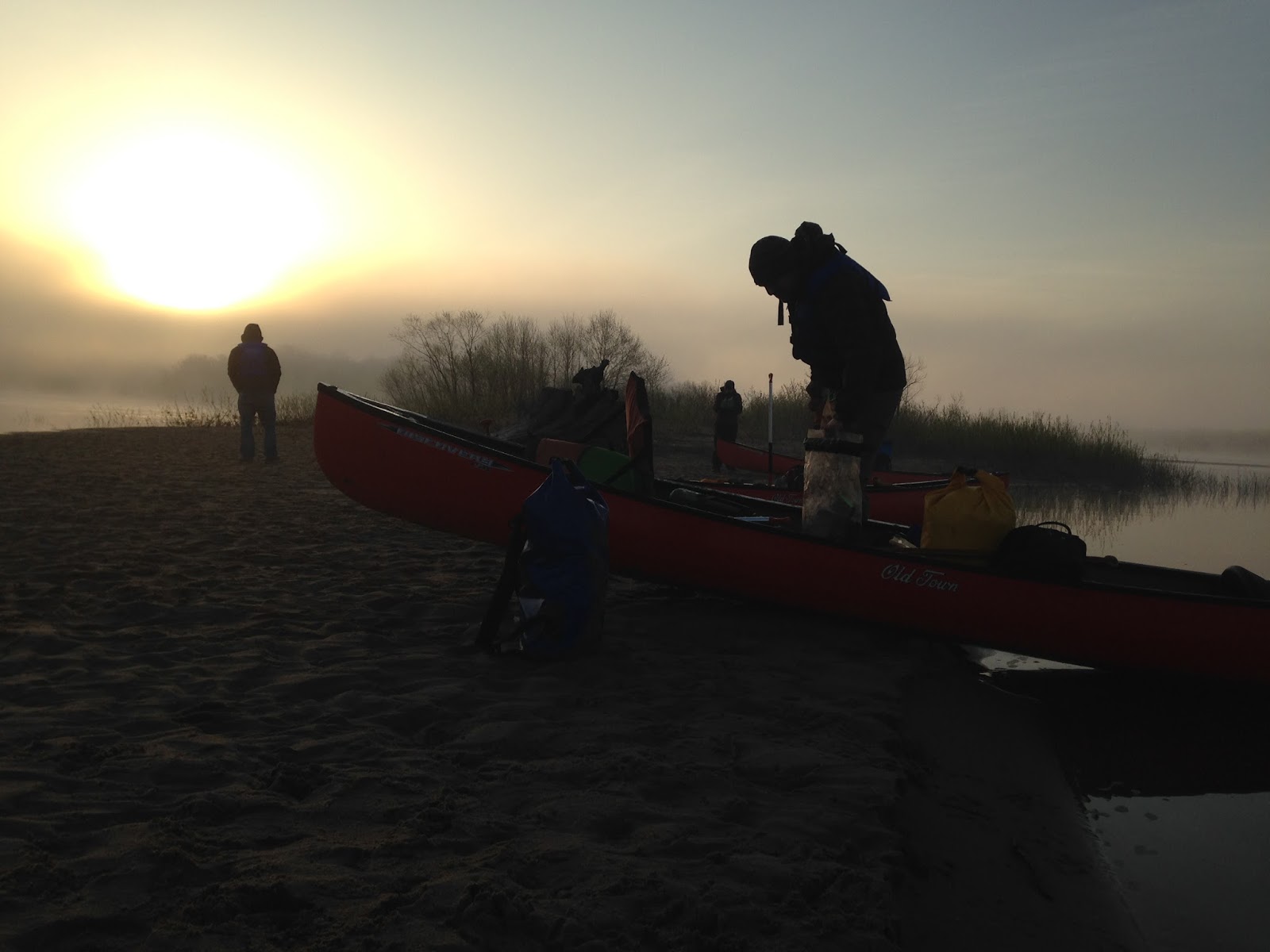
In 2014, six of us organized to give the challenge a shot. We
staged vehicles at various boat landings along the river (for safety reasons)
before setting out from Prairie du Sac at 1:30am. The luminous moon lit our way
before dawn brought daylight to the river bottom. The lack of sleep caught up
with us as we began to tire. Added to the mix, my elbow was giving me fits.
After much deliberation, we bailed at Boscobel, having paddled 62 miles in 16 hours.
Learning from the first attempt, we planned a rebuttal this
year. Only 3 folks took another shot at the Lower Wisconsin. Instead of trying
to fit the 92 miles in on a single calendar day, we decided to have all the
cars staged the night before and camp in Prairie du Sac to enable an early
start. A decent night’s rest would help, right?
 |
| Taking a break on the 2014 trip |
Matt, Jamie, and I, hit the water at 6am. Dawn had arrived a
few hours earlier. Fishermen were strung along the shore, casting their wares,
hoping to snag a big one. Our two canoes glided out into the river, still
churning from the nearby dam.
Landmarks were slowly checked off as the morning went on; the
Hwy 60 bridge, then Hwy 12, Ferry Bluff, and Spring Green. The water level was
quite a bit lower than the previous attempt, forcing us to work harder for each
mile. Our spirits were up though, thanks in part to a tailwind. We started to
set goals to reach landings with the baseline set at 5 miles an hour. When we
hit a goal, we’d let the current take the canoes while we snacked and took a
break.
Muscles began to ache, but onward we pushed. The pulls of the
paddles through the water became a metronome - a regular telling of time. My
mind fell into a trance, not focusing on paddling, not focusing on the
surroundings, it began to drift. It’s like an inner peace. No worries, just
Being. Songbirds flitted about, eagles stood sentinel and cranes groused
whenever the canoes came too close.
 |
| Setting out from Prairie du Sac |
Over those 92.3 miles, there are only 13 bridges crossing the
river (only 9 are roads, 4 are for trains). The wide flood plain helped dampen
development along the banks. Even the rim of the river valley, cut down over
millennia to its present state, is sparsely populated with houses. Sandbars,
trees, birds and poison ivy reign supreme. It’s quite the resource in southern
Wisconsin. A serpentine river, devoid of barriers, protected for perpetuity.
Was the meandering pace of the river a creation of the vast
damming upriver? Jacques Marquette commented on the danger of the shoals in
1673, but have the dams made navigation worse? The Lower Wisconsin has ambled
along for thousands of years, but has the hand of Man made it worse? Sand has
choked the river, pushing the channel this way and that, always presenting
sandbars for canoeists to navigate around. Humans cared little about protecting
rivers and the ecosystems they harbored when erecting dams at a furious pace in
the 20th Century. Hydro dams fed our appetite for electricity and
“helped” protect against destructive floods. Of the 4,700 dams on Wisconsin
rivers and streams, only 13% were built for power generation, half were built
for recreational purposes - creating lakes and reservoirs.
The counter to that argument is that those floods helped flush
sediment from the river, allowing a freer flowing river. The mighty Wisconsin,
now harnessed by those 26 dams, can become stagnant in the aridity of August as
it chugs towards the Mississippi.
 |
| One of the few bridges across the LWSR |
We were feeling good when we reached Boscobel – the ending
point on our previous attempt. A supposed quick pit stop to grab dinner, turned
into an hour, dusk settling in by the minute. It was 9 o’clock by the time the
armada set off again. Not more than 10 minutes later, questions arose on
whether this was a smart idea. Headlamps were futile in the engulfing darkness.
We could continue blindly downstream, hoping we didn’t hit an island or get
tangled in a strainer, or we could find a sandbar and take shelter for the
night. The latter (and more prudent) option won.
We set up camp and lit a fire (I feel like fire-building and
map reading are two of my stronger attributes). Before too long, heads hit
makeshift pillows and sleep arrived. A short time later, I awoke to the
flapping of the tent rainfly. Annoyed, I staked out the guy lines and settled
back in my sleeping bag. Sleep would not come. The wind picked up even more,
pulling all the stakes from their tenuous hold in the sand. The only thing
holding the tent in place was my listless body. Not good. After 3 hours of
sleep and 2 hours of lying there, I gave up. I packed up my tent and started a
fire. Dawn was breaking.
Before long an honest fire was flickering, helped by the
natural bellows of the east wind. The cloudy sky contrasted with the pastel
greens of spring along the river. I wanted to take a photo but my phone decided
it had to update at that moment and wouldn’t let me open anything unless it had
a Wi-Fi connection (First world problem).
 |
| Be sure to bring cans with you, glass is not allowed on the LWSR |
Shortly after 6, we dipped our paddles back into the Wisconsin.
My muscles ached in the same places they had the day before, the restless night
had failed to recharge. The east wind pushed us downriver, boosting our speed
and attitudes. Miles ticked off as we continued avoiding sandbars and the stray
log snagged on the bottom, remnants of higher water.
The final 10 miles of the Wisconsin River cozies up along the
valley walls - a brunette ribbon amongst the verdant, tree-covered hills. We
drifted under the Hwy 18 bridge at Bridgeport – the narrowest point of the
river for the final 30 miles - as snacks made their way around the canoes. Our
journey was nearing the end. The bluffs of Wyalusing State Park rose to the
south, bringing memories of summers spent living and working at the park,
building and maintaining the hiking trails.
Without fanfare, our canoes slipped into the pull of the
Mississippi River. After 19 hours on the river and 30 hours total, we had
reached our goal, just not in the hoped for time. Canoeing the Lower Wisconsin in 24 hours is
definitely achievable, but not by us on that trip. Perhaps another attempt will
bear the fruit.
We paddled the last few miles down to Matt’s van at the
Wyalusing Beach landing. Canoes were given a quick cleaning and strapped on the
van, awaiting their next adventure. We headed back upstream to find our parked
cars and inspiration to give the 24-hour challenge another shot.