It was Tuesday, October 23, just over a day from the start
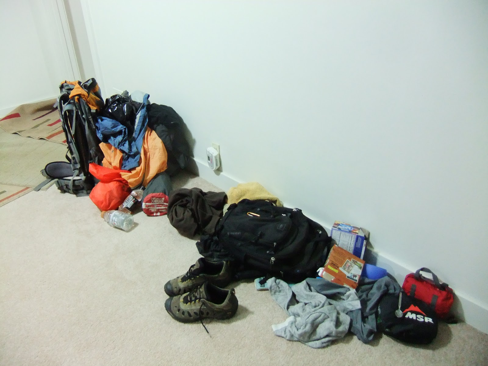
of a hike of the Border Route Trail and I had nothing ready. My gear, both probable and luxury items, was
strewn about Brad’s house, waiting to find the “take” or “leave” pile. I had experience going on a multi-day
backpacking trip, but I forget to keep track of what I brought so I have to
start from scratch each trip. To help in
deciding what to take, Brad had a scale so I could weigh my gear. Many cringe-worthy moments occurred as I
weighed item after item, always finding things a lot heavier than I thought
(and hoped) they were. My base weight of
backpack, tent and sleeping bag came in at 15 lbs. How did I ever finish my hike of the Ice Age
Trail? After an hour or two, my pack was
pared down to what I deemed the essentials.
Brad picked me up at Devil’s Lake the next day after work,
the temperature balmy in the mid-70s. We
headed up to my parents house in Eau Claire for the night so we didn’t have as far
to drive Thursday morning. After getting
Brad situated, I headed out to the bowling alley to meet a few friends,
intending to be home at a decent hour.
Needless to say that did not happen as I bowled a couple games and sat
at the bar for a bit longer (In the second game, I was at 30 after 4 frames and
somehow ended up with a 144). I got home
late and finally finished getting my pack set.
It was going to be a rough Thursday.
The Border Route Trail follows the US-Canada border in
Northern Minnesota and when you’re talking that far north in Minnesota, you’re
talking about the Boundary Waters Canoe Area and Wilderness (BWCA). The BWCA also happens to be my favorite place
in the world. I’ve canoed on the lakes
during open water and trudged through the snow on those same lakes in the
winter, but I’ve never hiked the trails that span the Wilderness. The two main trails through the BWCA are the
65-mile Border Route Trail (BRT) and 35-mile Kekekabic Trail (Kek). Together, they wind their way through 100
miles of Northwoods beauty, most of which is in the Boundary Waters.
Two and a half hours of sleep is enough right? Well I was going to find out as Brad and I
hit the road at 6:30 Thursday morning amidst a storm bringing rain, heavy at
times, and brilliant lightning. I turned
on my GoPro to get some video of the journey up, only to find it dead. What?!
I thought I had charged it the previous evening, but I was wrong. My dream of a great travel video was gone by
the wayside before we even started.
Ugh.
We arrived in Grand Marais at 11:30 and met up with
Chet. His brother Gordy and Gordy’s wife
Judy graciously offered to be our shuttle.
We drove to the Eastern Terminus of the Border Route Trail, dropped
Brad’s car off and hopped into Gordy’s van to head to the Western Terminus on
the historic Gunflint Trail. Snow buntings dotted the roadside as we bumped
along the gravel forest roads. The
temperature kept dropping, allowing what remained of the rain from the morning
to turn to snow.
Gordy’s minivan rolled to a stop at the Western Terminus
just after 2pm. We got out to make our
last preparations. I weighed my
backpack, afraid of what the scale might read.
29lbs. 13oz. Not bad! (This included about 8lbs. of food, plus the
quart of water I had) Brad and I had a
nipper of his Seagram’s Dark Honey Whiskey to christen the start of the hike. It was about 2:30 and 32 degrees with a
gentle snow falling as Brad, Chet and I set out on our trek.


We were immediately welcomed into the North Country with a
bleak landscape devoid any living trees taller than myself. The barren wasteland of blowdowns and
fire-decimated forest continued across the rolling hills. The “Big Blow” of 1999 was a derecho with
winds in excess of 90 mph that flattened nearly 400,000 acres. Being a federally designated Wilderness, it
took an act of Congress to allow chainsaws into the Boundary Waters to re-open
portages and trails. The Ham Lake Fire
followed in 2007 and burned 76,000 acres through the blowdown area.

The desolate moonscape was soon punctured by a tall, narrow,
black rock rising out of the ground like an obelisk placed by a culture
long-since forgotten. This out of place
landmark was Magnetic Rock, uplifted at a 90-degree orientation, and so named
because of its effect on a compass. The
starkness of the scenery with the pearl-white snow sticking onto the blackened
tree trunks accentuated the otherworldly feel of Magnetic Rock.
 |
| Magnetic Rock |


We continued on, tracking on the easily followed trail,
through a forest only beginning to rebound.
The thin soil and close bedrock make for tough beginnings for new trees
and plants to take root. The wind
continued to howl across the naked ridges as the snow was still falling, cloaking
the long view in a white falling mist. I
imagined Chet as Gandalf walking up the snowy mountain Caradhras, saying things
like “There’s a fell voice in the air” and “we must go on!”
Eventually we saw Gunflint Lake in the distance. It bobbed and weaved into view, more
glamorous each time. The Border Route
Trail interchanges with cross-country ski trails on the western end so we got
the GPS out a few times to verify that we were on the right path. We came to a river and Brad was all set to
ford it, but I suggested using the bridge 50 yards downstream.


Living trees began to enclose on us at the end of the day,
helping to darken our path prematurely.
We made it to Loon Lake and the potential “campsite” at 6:30. The potential campsite was the turnaround
for the Loon Lake boat landing (we weren’t in the Boundary Water quite
yet). Well, it was good enough for
us. We pitched our tents, had a pull of
whiskey and turned in early (I couldn’t use my left hand because it was so cold,
perhaps I should’ve worn gloves). Our
first day on the Border Route Trail ended 8.37 miles from the trailhead (plus
another 0.3 miles to the “campsite”). We
had hoped for a couple miles, but over 8 was a bonus. It was a good day.
DAY 2
We woke to a dreary, cloud-filled morning, and ate
quickly. My socks from the day before
were wet, but I was loath to let both pairs of socks get wet, so I put the wet
ones back on. It was not pleasant. We packed up and left by 7:30. Getting back to the trail, Chet realized he
forgot his thermometer at camp so he went back for it. My feet were bordering on frozen so I
continued ahead to generate some heat.
The snow from the day before beautifully carpeted the land and made the
trail stand out like an unfrozen stream in a frigid wilderness.


Shortly, I arrived at an awesome overlook. We had spotted it the day before in the
twilight and thought how sweet it would be to climb the acme and take in the vista. Little did I know, this would be a common
theme along the Border Route Trail.

Throughout the morning we had small amounts snow, sleet and
rain, continually changing the footing on the trail. We trudged through more of the blowdown,
fire-scarred terrain, experiencing more overlooks. There was life in the desolation though as
birds flittered about looking for a meal – chickadees, black backed
woodpeckers, ravens, and grouse all showed themselves. It was remarkable how far you could see with
no trees to block the view, just rolling hills with lakes in the valleys for as
far as the eye could see. With our packs
on in the stark landscape, we looked like a roving band of Quasimodo’s cousins.


We arrived at our first landmark of the day, Bridal Falls,
shortly after 11 AM, 15 miles into the trip.
Water bottles were refilled, snacks were brought out and a few pictures
were taken as we rested a bit.
 |
| Bridal Falls |
Soon we were officially in the Boundary Waters and the
effects of the wind and fire maelstroms began to disappear. Spruce, fir and pine trees colored the way
with their shades of green and popple, maple and alder brush filled in the rest
of the view with their empty branches.
We crossed the Laurentian Divide (my favorite divide), which separates
the Hudson Bay watershed from Lake Superior’s. The forecast before the trip predicted sunny
skies for most of the duration of the trip, but forecasts have a tendency of
being wrong. The sun was shyer than a
kid at their first day at a new school, hiding for most of the day.

As we traveled further east, the trail went up, up, up and
then down, down, down and back up again, like we were on a roller coaster, only
with our feet providing the power. The
ooh’s were replaced by oww’s as our bodies began to ache (at least mine) but
the ahhh’s were still ahhh’s, as we were graced with the Rose Lake
overlooks. When deciding which trail I
wanted to hike between the Kek and BRT, the vistas at Rose Lake were the
deciding factor. I wanted to stand on
the edge of grandeur and gaze upon the miles and miles of unbroken forest and
wilderness lakes that Native Americans, Voyageurs, and Sigurd Olson came to
love and worship. I was not
disappointed.

The views from the rocky cliffs expounded the enormity, the
vastness, and the desolation of our setting.
The sheer faces dropped precipitously to the lowlands surrounding the
lakes, hemming them in, but granting us the bird’s eye view I was
coveting. I scampered from rock to rock
trying to find the best perspective. The
perfect aspect was there somewhere, but I failed to find it. I did find the picture from the Border Route
logo though and we snapped a few photos to frame the memory. (Here's the link to the rest of my pictures)
 |
| Rose Lake Overlook |
 |
| Rose Lake Overlook |


The afternoon was growing long and there were more miles to
pass underfoot before day’s end so we moved on (myself very reluctantly). We had different gaits and I found myself in
the lead when I arrived at Portage Falls.
I snooped around while the others caught up. The fading light cast the waterfall in a
demure setting; it was an understated beauty.
Brad and Chet caught up, but the signage was lacking as we took the most
obvious path. Ten minutes later, Brad
called out that according to the GPS, we were on the wrong path. Shit.
The darkness was slowly beginning to envelope us as we headed back to
find the correct route.
 |
| Portage Falls |
With the Border Route Trail reclaimed, we continued into the
evening, pushing for a campsite along Rose Lake. I was being stubborn and refused to turn on
my headlamp until need be so I hiked along the trail, my eyes straining to keep
me on the right path. The uplands
allowed easy walking sans light (for me) but when the trail began its descent
to the lakeshore, the white pines were too intimidating to the moonlight,
completely blackening the route.
We got to the Rose Lake West campsite, but the site
nonplused Chet and Brad so we pushed on.
The trail became more muddy and difficult to navigate as we went
on. Legs were weary and packs were heavy
when we staggered into the Rose Lake East campsite just before 8. Holy Buckets.
We traversed more than 20 intimidating miles over 12 hours, draining our
energy and expectations of the journey.
It was a long day, but camp had to be set up and a fire started. Brad and Chet set up the tents while I
scoured the woods for dry timber to get the fire started (I’m very particular
with the ingredients I use to get a fire going). Within 15 minutes, the tents were set up and
a small fire was going. The clouds began
to thin, allowing the stars to come out and the temperature to drop as sleep
befell camp.

DAY 3
Overnight a snow fell, blanketing the tents and campsite
with a cloaking shield of white, blending trail and forest into one. It was 28.2 degrees and we got a late start,
as the Minnesota John (toilet) was a hot commodity. Once our packs were saddled and feet moving,
we quickly came to our closest encounter with the Maginot Line of the Northwoods
– The U.S.-Canada border. I’ve had my
share of disparagements and disagreements with the Canadians, but it was hard
to tell the difference between the two countries. It seemed like an arbitrary line and I hated
it.

 |
| Canada on the right, US on the left |
Throughout the day, Chet and I talked about our hikes, IAT,
AT, PCT, Superior Trail (Most of those were Chet of course). He hiked the Superior Trail this fall and is
doing it again next year, but not before I sneak it in next spring. A friend is getting married in Duluth so I
figured I might as well hike from Canada to it (wearing a tie of course).
 |
| Canada |

More overlooks greeted us along the way, continuing the
grandiose theme of the BRT. The sun
peeked out for a bit, only to go back into hiding. Brad had tweaked his knee the day before on
the many ups and downs and was laboring with the continued elevation changes of
the trail. Chet and I stopped for lunch
at a portage crossing and waited for Brad.
It became apparent that he wouldn’t be able to make it all 65 miles, so
Chet and I discussed our options and created a contingency plan.


Brad met us after ambling down the trail and we tossed out a
few ideas. We could stick together and
figure something out when we get out of the Boundary Waters and to a road, some
20 some miles away or have one of us split off and go ahead to hitch a ride and
bring the car around to the first road crossing. We decided our best bet was for me to go
ahead and get the car. I mentioned that
one of the first rules of survival in the bush is to stay together, Chet
responded with a “Screw the rules.”
After trading tents with Chet, I moved on down the
trail. Alone. My goal was the Pine Lake campsite, 9 miles
ahead, which would leave me only 7 miles to the Arrowhead Trail the following
day where I hoped to hitch a ride to Brad’s car (the Arrowhead Trail is a road). It was different hiking alone, my mouth
stayed shut and comments kept silent. I
wanted solitude in the Boundary Waters and finally had it, but was not how I
wanted to attain it.

The Border Route Trail was scantily marked while traversing
the BWCA. A scrap of blue ribbon would
appear once every 15 miles or so. Some
intersections were marked with a sign while others were not. Thanks to the maps and cheat sheets Chet
made, along with understanding how portages work, I was able to continue on,
confident I was on the right path.
 |
| Can you see the blue flag? |
Walking alone let my mind wander. What day was it? It didn’t feel like any day. Did it really matter? Civilization seemed so far away up here. The closest people to me may have been Brad
and Chet, 6 miles back on the trail.
Awesome.

It’s quite satisfying standing on an overlook, hundreds of
feet above a lake and see an island in the distance. You take a picture and keep walking. An hour later, after going up and down a few
times, you come to another overlook and that island is now behind you now. You trace the route you just took through the
woods and ridges, marveling at how far you can go if you keep putting one foot
in front of another.

Walking over the rough terrain for so many miles, I noticed
how you never look exactly where your foot is stepping; you’ve scoped it out
already and are looking two or three steps ahead, like chess. You remember the roots and rocks and adjust
your steps without even knowing it.
Pretty cool.


I arrived at camp at 6:10 after hiking 17 miles, set Chet’s
tent up, and got my sleeping gear in order.
A fire was built and water retrieved from the lake (iodine tablets
tonight!). My dinner of peanut butter
and tortillas (classic hiker meal) was classed up a bit by toasting them over
the campfire.


My achilles had been hurting earlier in the day, but faded
into the background as I looked back on the day. I had stopped at a vista and looked up to see
which way the clouds were moving and they appeared to be going straight up (I’m
not a meteorologist, but this doesn’t seem right). One of the bigger ascents brought forward
images of Minas Morgul (up, up up!).
More importantly, how was my camera still functioning? I had taken over 200 photos with temperatures
never rising above freezing so the battery should be on it’s last legs, but
miraculously the pictures kept coming (I’m going to attribute this to the
camera gods after my GoPro battery was a failure).


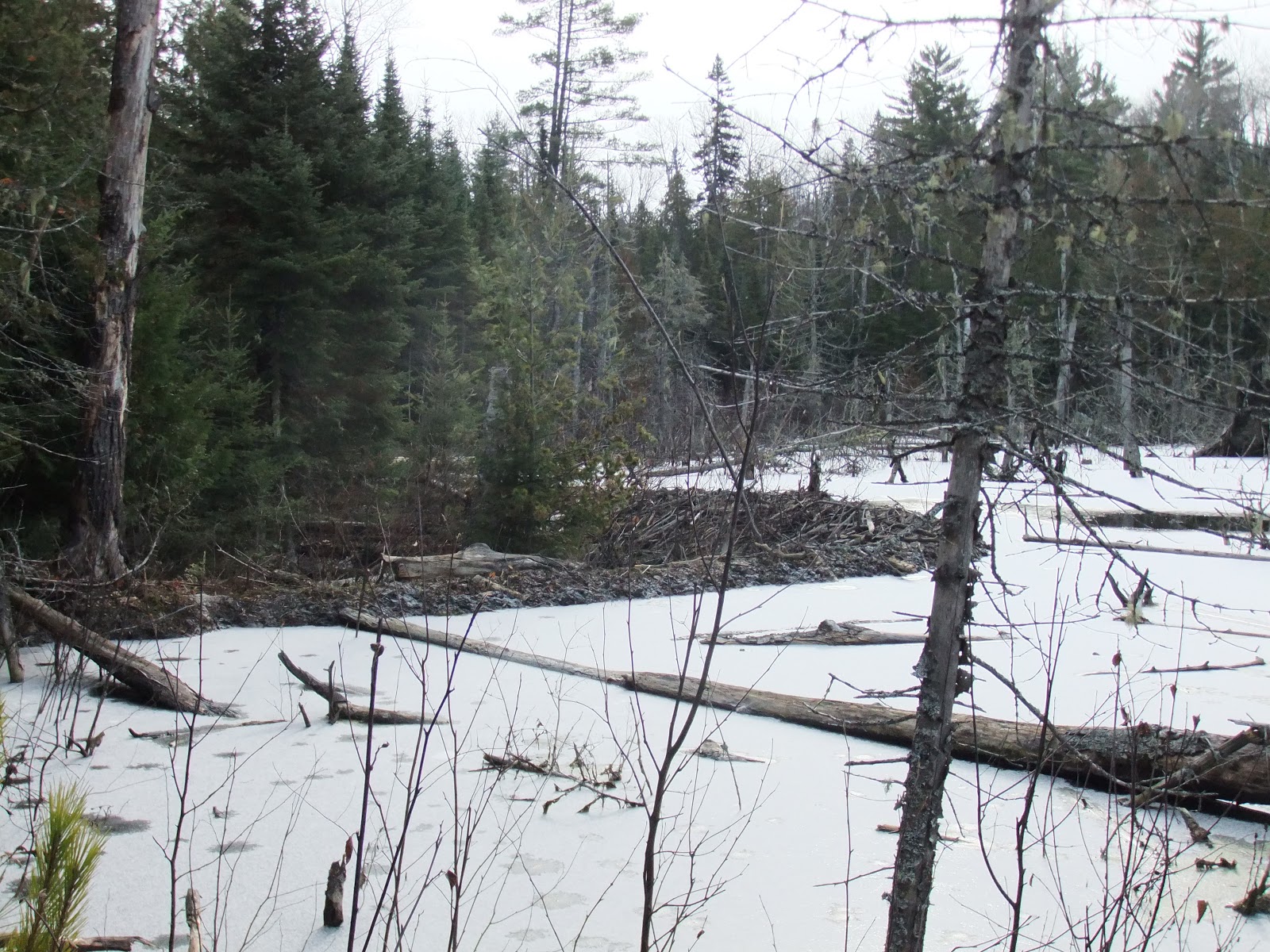 |
| Awesome beaver dam |
I’ve spent many nights in the Boundary Waters, but never one
by myself. While I’m up here, I think
about how I need to get back. The sights
from the Border Route Trail had greatly surpassed my expectations. I’d been to the Boundary Waters 8 other
times, but never on a hiking trail and never this far east. It blew my mind that something this beautiful
was so close. It’d been like Devil’s Lake
times 50. The lakes were bigger (and
more pristine), bluffs bigger (and a ton of them) and no one else around to bug
you (hiking in late October may have helped).
I love the BWCA; it’s my sanctuary.
 |
| Inside Chet's tent |
DAY 4
My dreams were weird like usual. This time I was at the Super Bowl (the
Packers weren’t even playing) and kept running into people I knew. Small world I guess. It was a long night as sleep came in fits and
bursts. Light streamed through the tent,
the moon was out. It was clear. It was cold.

Morning brought clouds and more wind and flurries. Chet recorded 23.9 degrees at his campsite,
but I think it was colder. Camp was
picked up and I went about my usual morning business by paying a visit to the Minnesota
John. During my morning constitutional,
I thought about how no matter the temperature, I’m never cold while using the
toilet. Interesting (or maybe too much
info?).
 |
| Minnesota john |
The day began with a mile long ascent and soon a good sweat
was trying to build up. As Les Stroud
says about winter activities in the middle of nowhere, “You sweat, you
die.” I did my best to cool down without
stopping my feet. Jacket was unzipped,
hat and gloves came off, shirt untucked, and if that didn’t work, I lifted up
my shirt to let the cool air in and put my cold hands on the small of my back
(this last trick felt pretty good).
I stopped for a break at the last overlook in the BWCA on
the BRT. The light snow from the morning
showed which lakes had froze over in the night.
Perhaps that was the last time they’d be ice-free until spring. I tried taking a sip from the water bottle,
but it had ice in it. I had to use my
lips to strain the water like the baleen of a whale. It was sad to leave the Wilderness, but there
was still 14 miles of trail left.


 |
| I look so happy |
I got to the BRT Trailhead on Arrowhead Trail at 12:10 and
started walking down the road towards the car, having no idea how far it was (I
didn’t have a map of the roads). I had
never hitchhiked before so I didn’t know what to expect. I thought I looked liked a decent enough guy
(or at least someone who looked like they belonged up there) and had a good
reason for thumbing a ride so one shouldn’t be too hard to come by right? One car drove by and another 30-45 minutes passed
before the next car came. The truck pulled
over and I talked with the lady for a few minutes. I felt pretty confident about getting a ride
when she said someone going my way could give me a ride. She wished my luck and drove on. Hmm, maybe this wasn’t going to be so easy
after all. Another car passed with no
luck.
Eventually a minivan pulled over and I gave her my sob story. She lived up there but had never heard of the
road I was looking for, but I coaxed her into giving me a ride. Shirley had Hall and Oates on the radio and
we talked about this and that for the 10-minute drive (She called the road
Brad’s car was on something else). Her
son, who was my age, worked as a land surveyor out of Grand Marais. When we got to Brad’s car she almost offered
a few tomatoes she had purchased in town but decided she wanted them more. I didn’t blame her and we parted ways. What a nice lady. Thanks Shirley! I got into Brad’s car and looked into the
rearview mirror and found I had a blood-crusted nostril. Well, that didn’t help my appearance.
I headed back to Border Route Trail crossing on the
Arrowhead Trail and measured how far I walked with the odometer. I made it 5 miles before Shirley picked me up
and if she hadn’t come along, I probably would’ve had to walk the whole
way. It was Sunday so I searched for the
Packer game. From past experience I
knew, thanks to Lake Superior, I could pick up Wisconsin radio stations from
the North Shore. The Iron Mountain
station crackled to life (A Michigan station I know, but part of the Packer
Radio Network!) as I settled in to listen to Wayne and Larry. The game was boring and I nearly fell asleep,
but we beat the Jaguars (Larry picked on Wayne for his unenthusiastic “And
that’s the dagger!” call). I was about ready to go check the trailhead to
see if Chet and Brad had showed up (I couldn’t park at the actual trail
crossing) when the lady who had denied me a ride stopped by and admonished me
for sitting there. Two people were
waiting for me back there she exclaimed (she also asked if the old guy was my
dad).

I picked them up at 3:30 and we decided Chet and I were
going to keep hiking, leaving Brad to sleep in his car at the Eastern Terminus. We set off just after 3:45 (not before
playing musical tents once more) with Chet setting a blistering pace as snow
began to fall, heavy at times. He’s 70
and I did my best to keep up with him. I
wasn’t sure I could handle the pace anymore when he stopped for a break. Thank god.
We happened to stop at an impressive overlook with a huge cliff
dominating the view, across the border in Canada. It was quiet and we could hear the Pigeon
River (which is the US-Canada border here) cascading below us. The beauty along the BRT cannot be
overstated. It is just awesome. Vista and vista after vista, gazing out over
crystal clear lakes stretching for as far as the eye can see. It may be the most spectacular landscape I’ve
ever laid eyes on.


Continuing on, we encountered more and bigger blowdowns than
anywhere along the trail, breaking up our rhythm and slowing us down. We made it to camp just before 6, having
covered 6 miles in a little over 2 hours.
Not bad on this trail.
 |
| Looking across towards Canada |
 |
| Pigeon River doing it's best to hold those Canucks at bay |
We set the tent up across the trail so our hips could rest
in the dip of the tread. I thought this
was a good idea, but when I finally monkeyed into my sleeping bag, I realized
it wasn’t the best spot. I had trouble
finding a position that didn’t put pressure on my sore knee and tossed and
turned. As I was whining about my
situation I thought about how Brad had gutted it out for over 24 miles after
his injury. And these weren’t an easy 24
miles. This was over some of the
roughest terrain in the Midwest. That’s
impressive. He was hurting, but kept his
feet moving. It’s a testament to his
will. If Brad could fight on, I could
suck it up and get some rest. I fell
asleep only 6.5 miles from the goal.

DAY 5
Chet woke me at 6 to get moving. It was dark and cold, 22.3 degrees according
to Chet’s thermometer, when we set off, headlamps showing the way. We crossed two bridges early on as dawn
slowly ambled to the day. The blue flags
marking the trail were sparse (but not nearly as sparse as they were in the
Boundary Waters) so Chet let me lead (I guess he didn’t want to be responsible
for getting us lost). Daylight
increased, but the trail did not present itself any more distinctly through the
open grassy areas. We were able to tease
out the route and just when we were going to check the GPS, a blue ribbon would
appear hanging on a branch


We worked up quite a sweat trying to pound out the miles in the dawn’s early light. I set the pace and this time it was Chet who was thankful we stopped for a break. The overlooks were great since the sun decided to make an appearance (albeit brief). The hike culminated with a 270-degree vista, only one mile from the end. Wow. To the south, the Swamp River meandered through a wide valley. It reminded me of the Alaska I had seen in pictures and videos. Turning to the east and north, Canada lay sprawled out, undisturbed and sleeping in the cold, sun splashed morning, simply spectacular. I coaxed enough life out of my camera for a few photos and a video.


We made it the last mile and found Brad sitting in the
trailhead parking lot. It was 9:24 and we
had completed the BRT in less than 4 days (about 91 hours if you wanted to more
specific, with only 20 minutes of direct sunlight during those 91 hours). I had hiked over 70 miles with spurs, road
walking and wrong turns. Not bad. To add a bit to my hike at the end, I walked
down the road for a few hundred yards to the Superior Hiking Trail
Trailhead. I’d be back in the spring and
didn’t want to leave the gap between the two trails. We loaded our gear into Brad’s car and sped
off down the gravel forest road.


I was glad to have finished the Border Route Trail, a goal of mine and Chet was happy to add another trail to his growing list of accomplishments. While Brad didn’t quite complete the trail, he toughed it out for 52 miles, which is nothing to scoff at. Not many people can do what he did.
The beauty of the Boundary Waters from the Border Route
Trail caught me off guard. Seeing the
BWCA from a different angle made it even more beautiful than I remembered. It was like listening to your favorite album
and being able to hear it anew, to get a fresh take on it. The new perspective deepened my appreciation
for the Boundary Waters, which I idolized. Beauty is around us every day, but sometimes
we aren’t looking at it in the right light or we come in with preconceived
notions that spoil our thoughts. Taking
a step back and looking at something or someone with a new outlook can unlock
beauty that has lain hidden from you.

A few hours later, we arrived in Duluth and headed to
Fitger’s Brewhouse. It’s a tradition of
mine to stop there on either the way up or back from the Boundary Waters and I
was happy to bring Brad and Chet into the fold.
The food was great and beer even better.
It was the perfect ending to our journey.